
About Drvar
The municipality of Drvar, situated at an altitude of 400–1,962 meters, is surrounded by the mountains Osječenica, Klekovača, Vijenac, Šator, and Jadovnik. Covering an area of 589.3 km², over 68% of its terrain is forested. The region has a predominantly temperate continental climate, with long snowy periods from October to April. According to the 2013 census, Drvar has a population of 7,036.
Rich in forests and water resources, the main river is the Unac, stretching approximately 63 km, along with numerous springs and smaller tributaries. The area also contains unexplored lignite deposits and abundant timber, providing potential for sustainable forestry and wood industry development.
Historical Highlights
Drvar began developing as an urban center in the late 19th and early 20th centuries, thanks to its high-quality forests and timber industry. Under Austro-Hungarian rule, it became an industrial hub, attracting investors such as Bavarian entrepreneur Otto Štambaiz. Over the years, Drvar witnessed numerous uprisings and battles, including the famous local rebellions during the Ottoman period.
During World War II, Drvar became known as a “hero city” for its role in the resistance, especially on May 25, 1944, when German forces attacked in the airborne operation known as the “Raid on Drvar.” Josip Broz Tito recognized the courage of Drvar’s citizens and awarded the town the Order of the People’s Hero in 1974.
The war in the former SFRY (1992–1995) caused significant territorial and population losses, but Drvar’s natural and cultural potential remains, with development opportunities based on forestry, water resources, and its rich historical heritage.
Geography and Natural Features
Drvar is located in the southeastern Bosanska Krajina valley, with altitudes ranging from 400 to 1,962 meters. Its landscape features the Unac River valley as a central axis, surrounded by forested mountains. The geology is predominantly karstic, with limestone, dolomite, and lake sediments in the valleys.
The area is rich in water resources, including the Unac River, numerous springs, and three lakes (one natural, two artificial). The forests, covering over 60% of the municipality, include about 50,000 native pedunculate oaks, a key natural asset.
Drvar is relatively isolated due to limited transport connections, lying 120 km south to Šibenik via Knin, 80 km north to Bihać, and 125 km to Banja Luka. Its natural and historical resources make it a unique destination for forestry, eco-tourism, and cultural heritage development.
Tito’s Cave
Drvar, known as a “hero city,” is a symbol of the Yugoslav Partisan resistance during World War II. One of the most famous events in its history is the Partisan victory over the elite German paratroopers, known as the “Raid on Drvar”.
Located within the “25th May” Memorial Complex, Tito’s Cave is where Josip Broz Tito hid during the war. Each year, up to 10,000 tourists visit the cave, which was even more popular before the war, attracting up to 200,000 visitors annually.
At the beginning of 1944, Drvar became the center of the liberated Yugoslav territory, hosting the Supreme Headquarters of the National Liberation Army and Partisan Detachments, along with other key political and military institutions. The cave served as a military base and meeting place for Tito and allied military representatives.
On May 25, 1944, German forces launched Operation “Rösselsprung” (Knight’s Leap) to capture or eliminate the Partisan leadership. Tito and the Supreme Headquarters successfully escaped, and the operation failed, marking a key victory for the Partisans.
After the war, the cave became part of the 25th May Museum and a major tourist attraction. It was destroyed in 1992 during the Bosnian War but was rebuilt in 2006 with support from the U.S. Agency for International Development, reopening on the 62nd anniversary of the raid.
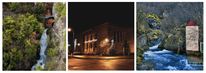
Bastašica River Source
Just five kilometers from the town of Drvar lies the source of the Bastašica River, located in the village of Bastasi. Although the river is short about one kilometer it flows through a natural sinkhole that extends deep underground, making it possible to dive in certain areas.
The source area is managed by the Drvar Forestry Department and is part of high conservation value forests (HCVF 4a and 4b), important for water protection and erosion control. Today, the area is arranged for visitors with marked trails, benches, protective fences, and a wooden bridge, creating a small eco-zone.
Bastašica is renowned for its natural beauty: crystal-clear greenish waters, waterfalls just a few meters from the source, and a mix of fast and slow-flowing sections that give it a unique charm. The water is drinkable along almost the entire course.
The river is rich in brown trout, and a mini hatchery has been established by SRD Unac, although fishing is permanently prohibited. Historically, the river hosted watermills and a grain mill, which are no longer in use.
Prekaja (Župica) Lake
Prekaja Lake, also known as Župica Lake, was formed by the construction of a dam on the Unac River, 17 kilometers upstream from Drvar, near the village of Župica.
Built in the second half of the 20th century to supply water for Drvar’s pulp and paper industry, the lake’s original industrial purpose ended with the closure of the factory. The dam, 24.74 meters high and 692 meters wide, also helps regulate water flow in the area, especially during floods.
Today, the lake covers 2 km² and is used for recreational activities, although there is no built infrastructure. It is also rich in fish, with species such as carp and chub being the most common.
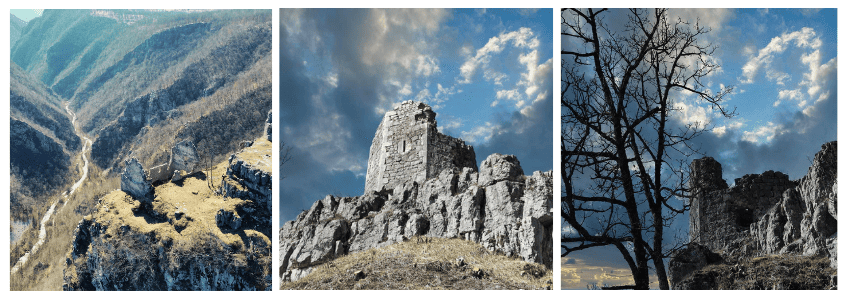
Crna Kraljica – The Hanging City
The Hanging City, locally known as Crna Kraljica (“Black Queen”), is a medieval fortress steeped in legend. It is said to be named after Queen Jelena, who was never seen without her black dresses.
The fortress features a hexagonal defensive tower within an irregularly shaped walled area, with multiple courtyards and residential structures. The central tower, approximately 12 meters high, once had a shingled roof typical of medieval Bosnia. Surrounding walls and courtyards measure roughly 60 meters in length and 33 meters in width, with walls up to 1.5 meters thick.
Ingeniously, the fortress was partially connected across the canyon using strong ropes—some for hauling water from the Visućica stream and others for transporting materials from the mountains—functioning much like a medieval cable system.
Crna Kraljica stands as a testament to the region’s medieval heritage and offers visitors a glimpse into Bosnia’s fortified architecture and legendary past.
Klekovača Mountain
Klekovača, with its highest peak Velika Klekovača at 1,962 meters, is the tallest mountain in western Bosnia. Stretching 43 km, it rises 1,500 meters above the Unac valley and 1,300 meters above the Petrovac basin.
The mountain is characterized by large rocky ridges, expansive meadows, and natural stone amphitheaters. It has long attracted attention for its natural and industrial significance, from early ecological studies by Đuro Pilar in 1879 to forest exploitation and the construction of a forest railway by Otto Steinbeis in 1893.
Hiking trails to the two main peaks, Mala Klekovača (1,761 m) and Velika Klekovača (1,962 m), were established around 1970. Today, the trails are well-marked and include a mountain hut. The summit was once restricted due to a military relay center, but now the area is open to hikers.
Klekovača is rich in flora and fauna. Its summit is covered with low vegetation and juniper, which gives the mountain its name. Nearby lies the Lomska Primeval Forest, a 298-hectare protected area since 1956.
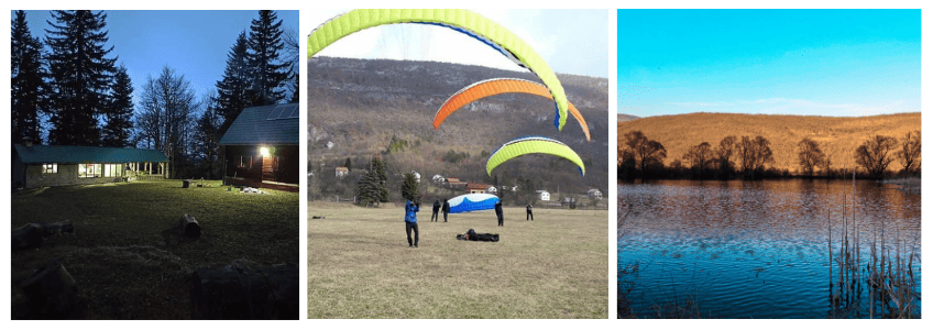
Paragliding Launch Site
Paragliding is a new and exciting sport in Drvar. The first flights began in 2017 when pilots from neighboring municipalities discovered the area’s potential.
Since 2018, the sport has grown with the development of access roads, a dedicated launch site, supporting facilities, and the organization of flights and informal competitions. The Drvar Paragliding Club was officially founded in early 2020 and currently has 15 members/pilots.
Launches take place at Kruškovac, located 4 kilometers from the main Drvar–Bosanski Petrovac road in the village of Podovi.
The Lagoons
The so-called “Lagoons” are a system of artificial ponds in the Drvar field. The four largest ponds are currently used for sport fishing, and a recreational area is located right by the water between two of the ponds.
Economic Development of Drvar
Between 1945 and 1991, Drvar became one of the most developed municipalities in Bosnia and Herzegovina, with a strong wood-processing industry at its core. The local population gained a reputation for their expertise in forestry and wood manufacturing. Other industries, including textile, machinery, and paper production, also flourished during this period.
At its peak, the RO “GRMEČ” wood-processing plant employed 3,500 people, while the RO “PAPIR” pulp and paper factory employed 680. Residents also worked in other industrial and service enterprises, public administration, and education.
The 1990s brought major economic and social changes with the privatization of state-owned companies. In Drvar, privatization occurred in several phases, including partial privatization in 1990–1991, recapitalization in 1996, and smaller privatizations later. A significant portion of the industry became controlled by foreign investors, notably Finvest CORP, leading to layoffs and social challenges after the closure of factories in the 2000s.
Today, Drvar hosts eight public enterprises and around 45 small and medium-sized businesses, mainly focused on wood-processing, forestry, and related services. Additionally, about 90 independent craftsmen operate in agriculture, trade, hospitality, and other services, continuing the municipality’s tradition of skilled local labor.
Learn more about us and our offerings here.