The Municipality of Civljane is a local self-government unit of the Republic of Croatia, located within Šibenik-Knin County
It was established on part of the former Knin municipality through the adoption of the Law on Counties, Cities, and Municipalities of the Republic of Croatia (Official Gazette NN 90/92 and 10/97). The municipality covers an area of 104 km², with limited infrastructure, partly bordering Vrlika and Sinj, and on the other side functioning as a “periphery” of Knin. It lies along the important Zagreb–Split traffic route and has scarce economic capacities. The municipality has a population of around 460 residents.
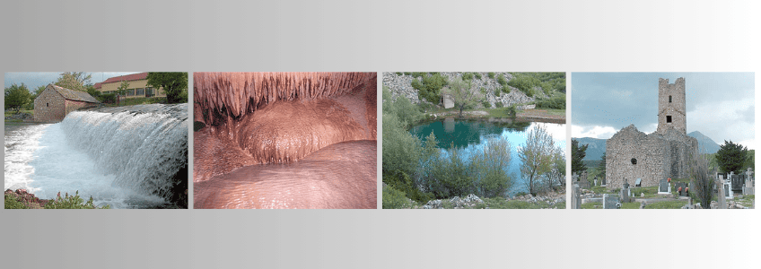
The area is characterized by high mountains and foothills that transition into plateaus, karst fields, and river valleys. Due to the reduction of livestock and decreased logging in recent decades, forested areas have been recovering. Fertile soil is found along the Cetina River, and the river’s springs are particularly significant as a hydrological natural monument. The sources of the Cetina are among the most beautiful karst springs in Croatia.
On the Sources of the Cetina
Near the small hamlet of Jarebice, three miles from Vrlika, at the foot of a marble hill, there are four main sources of the Tilurus, which locals call the Cetina. After a short flow, they all merge into a single channel, giving the place the name Vrilo Cetine. Historically, the region through which this river flows was a county governed by a local minor prince, but there was never a town called Cetina, despite some geographers, like Mr. Busching, mentioning it along with a non-existent lake. Porphyrogenitus referred to the Cetina County as Tzentzena.
When I first visited the river sources with Lord Hervey, two of them stood out. The hills between the Kozjak and Dinara mountains form fertile fields at their base and rise gently, connecting with Hrsovac Hill. The first spring is about a hundred steps from the hamlet, forming a semicircular base at the hill. A clear pond, almost hidden by cliffs and tree shadows, is about thirty feet in diameter; locals claim it has no bottom, as stones thrown in disappeared from view almost immediately. The water appears still, yet it flows abundantly into a river just a short distance below. Numerous trout, some weighing up to 25 pounds, emerge with the water, along with other fish. The passage through which they come is not visible from the horizontal viewpoint; it can only be seen from a high angle.
The second source, on the opposite side of the hamlet, is similarly a pond shaped like a horseshoe around a marble hill base. Its banks are less shaded, and it is said to be equally deep in the middle. From it flows a small stream that becomes significant when joined by the other stream and several minor ones from the hill’s base.
Underground Journey
The abundant water from these and other minor sources forms the Cetina, suggesting that the true sources may lie underground, with these visible springs being just branches of an ancient subterranean river. Observing signs of collapse on the slopes of Kozjak, Gnjat, and Dinara, Lord Hervey noted that sudden breaks likely caused the interruptions in the layers. We explored caves winding through the hills between the two ponds, which were once inhabited by humans or wild creatures. The caves are narrow, sharp, and dark, requiring crawling or stooping to pass.
In one cave, dripping water formed shell-shaped stalagmites with finely crafted crests, entirely natural but resembling artistic constructions. Pools collected layers of white mineral deposits, gradually forming new layers over time.
Frequent shifts and partial collapses of the rock layers reinforced the idea of an underground river. Eventually, we reached a natural arch under which occasional waters from nearby mountains flow through a wide underground channel.
Exiting the caves, I observed the high mountains surrounding the current Cetina course, undoubtedly carved by a river in ancient times, partly underground and partly on the surface, leaving behind abandoned rock beds. Locals noted a connection between the Cetina and the Buško Blato lake, some twenty miles away, suggesting a subterranean link, confirmed by the river’s abundant flow and the richness of fish in Buško Blato, used by locals under Ottoman rule for food and oil production.
Church Life
Church of the Holy Savior (Crkva Svetog Spasa) is the only Roman Catholic church in the municipality. The magnificent pre-Romanesque church of St. Savior, built in the 9th century during the reign of Prince Branimir, was commissioned by Count Gostiha. Today, it is rarely filled with worshippers except on the feast of Spasovo. The few local Catholics attend services at the parish church in Vrlika.
Roman Catholics belong to the Parish of Our Lady of the Rosary in Vrlika (župi GOSPE RUŽARICE iz Vrlike).
Parish Office: P. Mišura bb, Vrlika
Orthodox believers belong to the Vrlika Parish of the Serbian Orthodox Church (Parohiji Vrlika, SPC).
Parish Office: 30. svibnja 24, Vrlika
In 2006, Civljane municipality signed a contract with the Ministry of Culture for the protection of the cultural and archaeological site of St. Savior, Civljane, including archaeological work and structural restoration. The site was included in the 2006 “Program for Financing Cultural Heritage Protection.”
Church of the Ascension of the Lord (Holy Savior), the Orthodox church in Cetina, was built in 1940 as a foundation of Marko Četnik and his wife Jelena. It was renovated in 1974 with new bells and a stone fence around the churchyard. During the Croatian War of Independence, the church inventory was burned and destroyed.

Settlements of Civljane Municipality
Cetina
Cetina is a village in the Civljane municipality of Šibenik-Knin County.
- Altitude: 380 m
- Location: Situated in the Cetina region of central Dalmatia, within the Vrličko–Sinjska Zagora microregion, 6 km northeast of Civljane.
- Population: 123 (2001 census). Historical data: 1857 – 606; 1921 – 981; 1991 – 853 (of which 793 Serbs, 41 Croats, 2 Yugoslavs, 7 undeclared, 10 unknown).
- Area: 50.98 km²
- Subdivisions: Dolac nad Lukovačom, Dražica u Lukovači, Jarčište, Lukovača, Nad Glavicom, Nad Lukovačom, Njiva u Lukovači, Podić, Podunište, Sjenokos, Unište, Vaganac, Ždrilo.
- Economy: Agriculture, viticulture, and livestock farming.
Civljane
Civljane is the central village and administrative seat of the Civljane municipality, formerly known as Kozjak.
- Altitude: ~400 m
- Location: Located in the Cetina region of central Dalmatia, within the Vrličko–Sinjska Zagora microregion of southern Dalmatia, 61 km northeast of Šibenik.
- Population: 14 (2001 census). Historical data: 1857 – 474; 1921 – 1343; 1991 – 819 (of which 790 Serbs, 14 Croats, 2 Yugoslavs, 1 regional, 2 undeclared, 10 unknown).
- Area: 17.80 km²
- Subdivisions: Čitluk, Dubrava pod Kozjakom, Kotluša, Kozjak, Marjevci pod Kozjakom.
- Economy: Agriculture, viticulture, and livestock farming
To learn more about local administration, services, and community updates, visit the official website of the Municipality of Civljane.