History of Banovići
Banovići’s story begins long before its modern development, with legends and historical traces reaching back to prehistoric times. The earliest known settlement, “Gradina” in Tulovići, dates to the Iron Age, with fortified stone structures and evidence of early agriculture, animal husbandry, hunting, and primitive brewing.
During Roman times, the area was part of the broader Bosnian territory, with coins from emperors Caracalla and Gordian discovered locally, hinting at trade and military activity.
In the Middle Ages, Banovići was part of the Soli region, a border area often changing rulers between Byzantines, Serbia, and Hungary, and eventually integrated into the Bosnian state during the reign of Ban Kulin (1180–1204). The Bozicko Banovic stecak, a 15th-century tombstone, remains an important cultural monument and highlights the historical significance of the Banovic family.
During the Ottoman period, Banovići experienced migrations, social changes, and population shifts. Muslim families settled alongside the local population, shaping the region’s cultural and religious landscape.
The 19th century brought social unrest and uprisings against feudal oppression, while Austria-Hungary’s occupation in 1878 initiated industrial and mining developments. The first coal mines in Banovići opened during the Kingdom of Yugoslavia, accompanied by labor movements and strikes advocating workers’ rights.
During World War II, Banovići was part of the regional resistance, with partisans disrupting mining operations to weaken enemy resources. The town was finally liberated in April 1945.
The construction of the railway in 1946 connected Banovići’s rich coal deposits to major transport routes, marking the start of modern industrial development. The railway project, completed in record time, symbolized Banovići’s transformation into a significant mining and economic center in post-war Yugoslavia.
Geography, Climate, and Natural Features of Banovići
The Banovići municipality features diverse terrain shaped by geological formations. The area includes gently rolling hills covered with forest, as well as higher mountain ranges between 600–1,000 meters above sea level. The soil is composed of serpentine, marl, clay, and gravel, with a thin layer of humus supporting agriculture. The landscape is marked by valleys with gentle slopes and a series of low, elongated ridges.
The region’s main natural resource is brown coal, mined both in open pits and underground at several local mines, including Musici, Radina, Cubric, Solovi, Omazici, and Djurdjevik. Other minerals, such as magnetite, are found in areas like Borovci.
Banovići has a moderately continental climate with mountain influences in the southern areas. Winters are long, cold, and snowy, while summers are short and fresh. Average annual rainfall is 982 mm, rising to around 1,200 mm in mountainous regions, and relative humidity averages 73%. Fog is common in colder months, and the most frequent winds are north and east, accounting for 75% of wind occurrences. Annual temperature variations are moderate, with July being the warmest month and January the coldest. Early autumn and late spring frosts can pose risks to agriculture, especially orchards.
The area’s hydrography includes the rivers Spreča and Krivaja, along with smaller streams such as Draganje, Ostruznje, and Litve. These waterways flow west to east and feed into the Oskova River, eventually joining the Spreča. Water flow varies significantly depending on annual precipitation.
Banovići’s natural features offer a scenic and resource-rich environment, combining fertile valleys, forested hills, and mineral wealth with a climate suitable for diverse agriculture and outdoor activities.
Natural Attractions of Banovići
The northern slopes of Konjuh Mountain host several remarkable speleological sites. Among them are the Jaruska Cave, the Ponikva sinkhole in Gornja Trestenica, and three other unexplored caves.
One of the most notable caves is Pecinica – Puzovac, which has attracted hundreds of tourists and caving enthusiasts from Tuzla, Banovići, and surrounding areas. On the eastern side of Konjuh, near Stupar, there are about ten other speleological objects, the largest being in the village of Zenuni, stretching 320 meters.
Pecinica – Puzovac is located about 6 kilometers north of Banovići, near Kasumovići school, below the Puzovci hill, and on the right bank of the Turija River, offering visitors a fascinating natural and underground landscape.
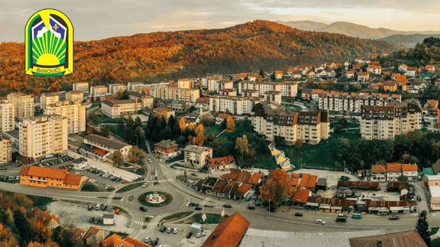
Banovići Today
Banovići is a mining town in northeastern Bosnia, covering 183 km² with a population of approximately 28,000. The town is situated on the northwestern slopes of Konjuh Mountain, along the main road connecting the industrial centers of Tuzla and Zenica, linking the Tuzla and Zenica-Doboj cantons. The municipality borders Lukavac, Živinice, Kladanj, Olovo, and Zavidovići. Banovići is 36 km from Tuzla and 110 km from Sarajevo, with a railway line connecting it to Brčko and the wider Bosnian rail network.
The local economy is centered on coal mining, employing 5,806 workers, with 4,280 unemployed. Banovići consists of 19 settlements and 74 hamlets.
Education is well-developed, with primary schools Banovići, Grivice, Banovići Selo, Seona, and Trestenica, serving a total of 4,867 students. The Mixed Secondary School Banovići is a modern facility with around 1,500 students, offering mining, electrical, mechanical, and economic programs.
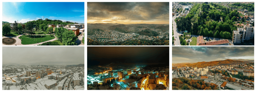
Banovići presents two contrasting faces: the first is shaped by long-term coal mining, altering the natural landscape; the second showcases pristine slopes of Konjuh Mountain, clean air, cascading waterfalls, natural and artificial lakes, rich flora and fauna, and excellent fishing spots. These natural attractions make the Banovići region a popular destination for visitors and nature lovers.
You can learn more about us here.