
The Municipality of Jajce is located in the western part of the Central Bosnia Canton (SBK/KSB), in the central region of Bosnia and Herzegovina (BiH).
The municipality covers an area of 363 km² and borders the municipalities of Travnik, Dobretići, and Donji Vakuf in the Federation of BiH (SBK), as well as the municipalities of Jezero, Šipovo, and Mrkonjić Grad in the Republika Srpska (RS). Compared to 1992, the municipality’s territory changed and was reduced by 33 km², as parts of Jajce were incorporated into the newly formed municipality of Jezero in RS following the signing of the General Framework Agreement for Peace in BiH, while a part of Mrkonjić Grad was added to the Municipality of Jajce.
The municipality is connected to other parts of BiH via the main roads M-5 and M-16. The Municipality of Jajce consists of 61 settlements organized into 27 local communities. According to the 1991 census, the municipality had 45,007 inhabitants.
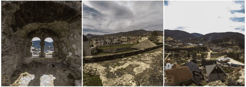
The municipality lies on the banks of the Pliva and Vrbas rivers at a northern latitude of 40º20’30’’ and an eastern longitude of 17º14’16’’. The terrain is hilly and mountainous. The municipality’s elevation ranges from 362.5 m (waterfall) to 1,400 m (Suhi Vrh). The town center of Jajce is at an altitude of 470 m at the fortress, while the Pliva Lakes are at 426.6 m above sea level.
Water Resources and Lakes
The Pliva and Vrbas rivers flow through the area, enriched with tributaries and abundant in freshwater fish. Five kilometers from the town are the Veliko and Malo Plivsko Lakes, surrounded by attractive water mills. These lakes are suitable for water sports such as rowing and kayaking competitions.
Mountains, Forests, and Wildlife
The surrounding mountains, dominated by Suhi Vrh (1,431 m), are rich in coniferous and deciduous forests covering 20,978 ha, or 54% of the total territory, and host diverse wildlife, medicinal plants, and areas suitable for winter sports.
The climate is moderately continental, with warm summers and cold, snowy winters.
Hydropower Potential
Thanks to its water resources, the Municipality of Jajce hosts two hydroelectric plants – HE Jajce I and HE Jajce II – providing an annual production of 225,454,000 kWh of electricity.
Mineral and Ore Resources
The municipality has several mineral and ore deposits, including bauxite deposits in the Poljana and Bešpelja areas. The surroundings of the town contain deposits of non-metallic materials suitable for construction, building stone in Komotinski Potok, clay in Divičani, and gypsum-anhydrite on the shore of Pliva Lake.
Archaeological and Historical Sites
Archaeological sites discovered in the town center indicate that humans lived in this area over 6,000 years ago. Sites from the Roman period are particularly significant, both in the town and its surroundings, including the Temple of Mithras and 4th-century necropolises.
Medieval and Ottoman History
Jajce was first mentioned in a written document in 1396, referring to the town’s founder, Hrvoje Vukčić Hrvatinić (1350–1416), as “conte di Jajce.” The name Jajce likely comes from the egg-shaped rock on which the fortress was built. In the 15th century, Jajce was the seat of the Bosnian kings, and in 1461, the last Bosnian king, Stjepan Tomašević, was crowned there. In 1463, during the Turkish campaign into Europe, Jajce was conquered and the king executed; his remains are preserved today in the Franciscan Monastery in Jajce. In the same year, King Matthias Corvinus captured Jajce, which remained the center of the Jajce Banovina from Prusac to Banja Luka until 1527. After 64 years of constant conflicts, the Turks retook Jajce in 1527, incorporating it into the Ottoman Empire.
During the Ottoman period, Jajce had several educational institutions, and the surrounding area hosted important transcription centers. The town had a water supply system and a large bath-hamam, the remains of which are still preserved. During the struggle for Bosnian autonomy from the Ottoman Empire, Jajce offered significant resistance under Omer Pasha Latas.
Austro-Hungarian Rule and Infrastructure Development
The Austro-Hungarian administration replaced the Turks in 1878. Jajce was connected to the rest of the Monarchy via the Jajce–Banja Luka road and the Jajce–Lašva and Jajce–Mliništa railway lines. The largest hydroelectric power plant of the time in this part of Europe was constructed, and the waterfall was illuminated as early as the 19th century.
Kingdom of Yugoslavia and World War II
During the Kingdom of Yugoslavia (1918–1941), Jajce was the center of a district. In 1943, during World War II, Tito’s Yugoslavia was established here.
Cultural Heritage and Tourism Potential
The area’s natural wealth, including the Pliva River, its lakes, and the waterfall, as well as the rich cultural and historical heritage (Old Town, catacombs, Omer-beg’s house, St. Mary’s Church and St. Luke’s Tower, the Temple of Mithras, and more), with a total of 30 national monuments, offers a unique tourist attraction in Jajce.
UNESCO Initiative
On the initiative of the Municipality of Jajce, the Commission to Preserve National Monuments of BiH submitted a proposal to the Presidency of BiH to include the town’s core on the prestigious UNESCO World Heritage List. In November 2006, the Presidency of BiH supported the initiative and forwarded BiH’s candidacy proposal for Jajce to the UNESCO headquarters.
To learn more about local administration, services, and community updates, visit the official website of the Municipality of Jajce.