Geographical Location and Setting of Kladanj
The town of Kladanj is situated in the central northeastern part of Bosnia and Herzegovina, covering an area of about 4 km², and forms an integral part of the Tuzla Canton. It lies on the border between central and northern Bosnia.
Kladanj borders five municipalities: Živinice to the north, Šekovići to the east, Vlasenica to the southeast, Olovo to the southwest, and Banovići to the northwest.
The town itself is located in the central part of the municipality, along the Drinjača River, at an altitude of approximately 560 meters. It is surrounded by the villages of Plahovići, Buševo, Vučinići, Mladevo, Konjevići, and Gojsalići. An important transport route, the Sarajevo–Tuzla road, passes directly through the town.
The Name of the Town
The name of the town of Kladanj originates from the Ottoman period and is derived from the word “klada” (log), for which there is an official interpretation. However, among the people, there are several explanations regarding the town’s toponym. For example, one legend about the origin of the name Kladanj tells of the Turkish advance westward through this area. In order to cross the Drinjača River, the Ottoman army improvised a bridge made of logs. During the crossing, one soldier drowned, and the town was given the name it still bears today.
History and Origin of Kladanj
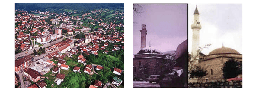
Kladanj was first mentioned in 1138 and throughout the Middle Ages functioned as an important settlement, recorded in both Dubrovnik documents and travelogues as one of the largest in the Tuzla region. Ottoman sources from 1469 mention its weekly market, and by the mid-16th century it had developed into a small town (kasaba) with notable landmarks such as the domed Hadži Balibeg Mosque (Kuršumlija) and a hamam.
During Austro-Hungarian rule in 1878, Kladanj became a district within the Tuzla region. The town originally developed at the confluence of the Ujiča and Drinjača rivers as a small community of forestry workers. With Ottoman influence, typical architectural and cultural elements were introduced, though most were later lost to fires and wars, leaving only a few preserved monuments.
Development in the Ottoman and Austro-Hungarian Periods
In addition to the two preserved mosques, Kladanj once had five more mosques, two mektebs (religious schools), three turbes (mausoleums), a madrasa, a musalla, and around ten inns (hans)—with some sources mentioning up to 26. The last inn was built in the 1960s.
The Austro-Hungarian administration introduced significant political, legal, and economic reforms, aiming to expand its capital interests, particularly in forestry. While some Ottoman officials remained, new settlers arrived officers, traders, craftsmen, and professionals, especially from Hungary, Austria, and Italy. Ottoman jemats, nahijas, and sanjaks were replaced with municipalities, districts, and counties. Kladanj developed into an important transport hub, with forestry becoming the main driver of the local economy and livelihoods.
Population and Density
In 1991, Kladanj had about 4,500 inhabitants: 87% Bosniaks, 10% Serbs, and 3% others. By 2004, the population was estimated at around 5,000, of which approximately 4,600 were locals.
In 1991, the town had 1,323 households with an average of 3.4 members each. Today, due to lower birth rates and an increase in the number of households (1,786), the average household size has decreased to 2.8 members.
Early Urban Development
Kladanj’s first major urban buildings were constructed during Austro-Hungarian rule, including schools, public buildings, the Konak, the Municipal building, gendarmerie barracks, and parts of the old čaršija. A hospital for chest diseases was built, and the town was recognized as a health resort due to its clean air and mountain climate.
In 1880, Kladanj opened its first primary school, and by 1910 it had a post office, telephone, and telegraph. During the socialist period, a mineral water bottling factory became an important local industry. The town was connected to the electricity network in 1955, and its water supply comes mainly from the Babovac spring. The first sewer system was installed in the 1960s, serving the town center.
Functions of the Town
Kladanj has a mixed economic structure. It serves administrative functions and acts as a market for goods produced mainly in surrounding villages. Some industrial facilities provide employment, although industrial development has largely declined.
The town’s main economic highlight is ŠG Šume TK – Sokolina Kladanj, which manages the region’s forestry resources and employs a significant portion of the workforce. In addition to the wood-processing industry, there are textile and smaller manufacturing plants. While many other businesses remain stagnant, recent positive changes offer hope for the town’s economic recovery.
You can learn more about Kladanj and its history in the tourist guide.
Top 3 Must-See Attractions in Kladanj
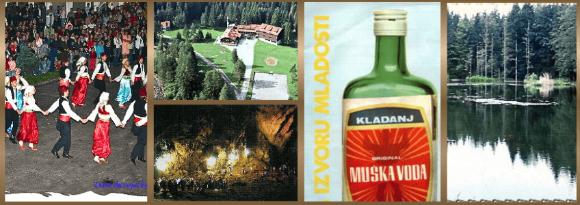
Muška Voda Spring & Hotel Complex
Relax at the famous Muška Voda mineral spring, known as the “Fountain of Youth,” and enjoy the hotel’s wellness and sports facilities in a serene forest setting.
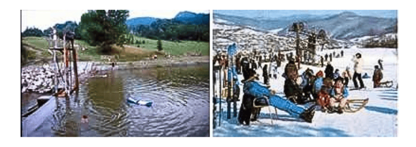
Gorsko Oko Lake
Explore the picturesque forest lake, teeming with fish and surrounded by rich flora and fauna—perfect for a peaceful day in nature.
Bebrava Cave
Adventure through the stunning Bebrava Cave, featuring impressive stalagmites, stalactites, and underground streams, offering a unique experience for nature enthusiasts and explorers.
Djevojačka Cave – History, Legends & Culture
Djevojačka Cave, located in the village of Brateljevići above the Bukovica stream, is one of the most popular pilgrimage sites during the St. George’s prayer cycle, attracting Bosniaks from Kladanj, the Drina and Posavina regions, and central Bosnia.
Legend tells of a girl who entered the cave with a spindle and water jug and never returned, inspiring local traditions and prayers for her soul.
The cave also contains medieval rock engravings, including riders, standing figures, animals, and a unique “winged man” figure, alongside Ottoman-era Arabic inscriptions.
Each year, the Days of Djevojačka Cave festival is held during the last week of August, celebrating the area’s religious and cultural heritage with poetry, music, art, film, and historical presentations. The cave remains a symbolic and meaningful site for preserving and sharing local tradition and culture.
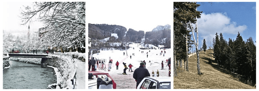
Ski Lift & Hiking in Kladanj
Kladanj’s rich forests, pleasant climate, and long-lasting snow make it an ideal destination for winter sports and hiking.
The modern Karaula Ski Lift, just 800 meters from the town center, features a 1,700-meter ski slope suitable for slalom and giant slalom, with a lift capacity of 1,200 skiers per hour. The lift’s upper station at 893 meters offers breathtaking views of the town, and the area also has a sledding track.
Beyond skiing, the surrounding mountains are perfect for hiking, foraging medicinal herbs, and collecting mushrooms. Popular hiking routes include Javorje, Konjuh, Ždrijepčev Skok, Konjušić, Krabanjski Krš, Papala, Jaračko Brdo, Bratilo, and Veliki Zelenboj. A mountain lodge on Javorje supports hikers, while the local hiking club “Muška Voda – Konjuh” organizes tours showcasing the natural beauty of the region.
Whether you seek relaxation, adventure, or a glimpse into history, Kladanj offers a unique blend of nature, culture, and tradition that leaves every visitor with unforgettable memories.
For more information, click here.