
Administrative History of Sapna
The municipality of Sapna officially began on March 18, 1998, when, following a decision by the Federal Parliament, the Municipal Council convened for the first time. Sapna was created by dividing the former Zvornik municipality into two parts: Zvornik in Republika Srpska and Sapna in the Federation of Bosnia and Herzegovina.
However, Sapna’s autonomy dates back to early periods of Bosnian history. People have inhabited the area since ancient times, and Sapna is mentioned as an administrative-territorial unit as early as the Middle Ages, often shown on historical maps as Župa Sapna.
During the medieval period, Sapna was an important communication and trade route between Zvornik and Teočak. Numerous stećci (medieval tombstones), found in settlements such as Hanđelici, Međeđa, and Gornja Sapna, testify to long-standing human presence. Under the Ottomans, Sapna became a nahija (district) within the Zvornik Sanjak (1478–1483). Its historical settlements are further evidenced by multiple cemeteries across the region.
Under Austro-Hungarian rule, Sapna belonged to the Zvornik district. During the Kingdom of SHS and later the Kingdom of Yugoslavia, it was part of the Zvornik district within the Tuzla County. After World War II, Sapna functioned as a municipal center until 1958, when the Zvornik district was dissolved and merged with Tuzla, incorporating Sapna into the Zvornik municipality.
During the Bosnian War, the area of present-day Sapna effectively organized itself and maintained autonomy as a free territory. Today, this history demonstrates that Sapna has remained a cohesive and historically significant region, both in the past and present.
Education and Culture in Sapna
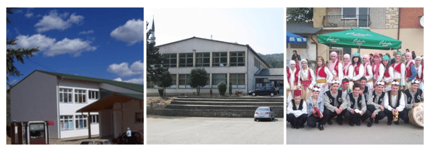
Sapna offers quality primary and secondary education through its central and branch schools, while students pursue higher education in Bosnia and abroad. The municipality fosters cultural life with BZK “Preporod” and the KUD Merak society, organizing folk festivals, performances, and literary events. Although Sapna lacks a cultural center and public library, local initiatives keep traditions and community spirit alive.
Geography, Natural Resources, and Climate of Sapna
Terrain
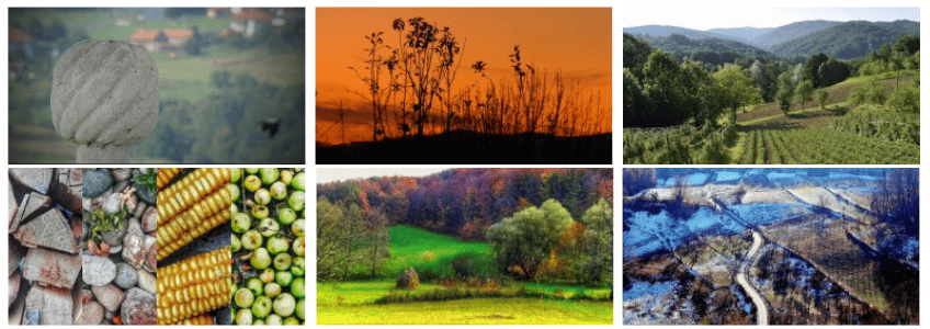
The municipality of Sapna features typical hilly and mountainous terrain with few flat areas. The land generally slopes eastward and partially northwest. The central area lies along the Sapna River and the regional road Zvornik – Priboj at an elevation of 147 m, while other settlements stretch north and southwest, averaging 300–400 m above sea level.
Rivers and Lakes
The largest river is the Sapna River, formed by the Rožanjka and Munjača rivers, which flows into the Drina. Other important rivers include the Brzava (flowing into Sniježnica reservoir) and the Tavna, along with numerous tributary streams.
In the northwest, the Sniježnica Lake partially belongs to Sapna municipality and is 12 km from the municipal center. Rich in fish and surrounded by unspoiled nature, the lake is ideal for fishing, tourism, and eco-activities.
Mineral Resources
The region contains coal, natural gas, and oil deposits. Sand, quartz, mineral waters, and building stones are also present, with some coal outcrops observed along riverbeds. While exploration has been limited, these resources offer economic and industrial potential.
Forests and Wildlife
Forests cover a large part of the municipality, mainly deciduous trees like oak and beech. Post-war forestry management focuses on sustainable logging and reforestation, often with conifers. Wildlife includes hares, foxes, deer, wild boars, and various birds, making the area suitable for hunting and eco-tourism.
Climate
Sapna has a moderate continental climate with four distinct seasons. Average annual temperature is around 12°C, with extremes from -15°C to 40°C. Annual precipitation averages 964 mm, mostly in April–May. The northwest winds dominate the region.
Air Quality
The area enjoys exceptionally clean air, as industrial emissions are minimal. Potential sources of pollution include small residential boilers and distant industrial plants, but overall air quality remains high.
Sapna – Development Potentials & Strategic Goals
Key Strengths
- Excellent geographic location
- Active workforce (~70% aged 15–64)
- Rich natural resources: water, raw materials
- Preserved traditional lifestyle
- Citizens employed abroad
- Strong local transport connections
- Basic infrastructure & education in place
- Health & social care institutions available
- Ecologically clean environment
- Organized local administration
Opportunities
- Business & tourism zone development
- Investment from citizens working abroad
- Wood processing & construction industries
- Fruit farming, medicinal herbs, and processing
- Livestock farming & mini farms
- Public transport organization
- Urban planning & riverbed regulation
- Gasification & heating projects
- Workforce retraining
- Cultural & sports facilities
- Improved healthcare diagnostics & education
- Municipal development agency
- Quality standards (ISO 9001)
Strategic Goals
- Ecologically healthy municipality
- Sustainable economic growth
- Modern infrastructure
- Planned urban development
- Recognizable cultural, sports, and educational institutions
- High-quality social & healthcare services
- Modern, transparent local governance with citizen engagement
Sapna is a unique municipality that combines a rich history, preserved nature, and an ecologically clean environment with developed education, promising economic potential, and an active local community, providing a strong foundation for sustainable development and a high quality of life for its residents.
You can learn more about us here.